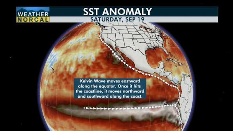
The way water moves in the world’s oceans is affected by a number of factors. We know the tides are primarily influenced by the gravitational pull of the moon, but wind and temperature can also affect how the waters of the oceans behave. On the surface, prevailing winds can push the water in one direction or another, but below the surface, variations in temperature can also influence the flow of ocean waters. In the Atlantic Ocean, warm water at the equator flows north along the coast of the Unites States and Canada before turning east toward Iceland. From there, it flows south along the west coast of Europe on its way back toward the equator. That current is known to oceanographers as the Atlantic Meridional Overturning Current or AMOC, but it is commonly referred to as the Gulf Stream. A Kelvin Wave In The Pacific In the Pacific Ocean, the prevailing trade winds near the equator normally push warm water west toward Australia and southeast Asia, but something out of the ordinary is happening this year. Because of a strong El Nino event, those prevailing winds are now calm or flowing to the east, which pushes those warm Pacific waters against the coast of South America. Blocked by that land mass, they turn north and south. A portion of that flow is now approaching southern California and is expected to reach San Francisco in about three weeks. This wall of warm water is known to scientists as a Kelvin wave, and yes, the name refers to the same Lord Kelvin who entered university at age 10 and gave us the Kelvin temperature scale. “You can follow [Kelvin waves] along. We see the higher sea levels along the equator, and when the wave reaches the coast of South America, it cannot continue to go eastward,” Severine Fournier, a research scientist studying ocean circulation at NASA’s Jet Propulsion Laboratory, told The Guardian. “So it goes north and south.” Here is an interview with Dillon Amaya, a scientist at NOAA, who does a good job of explaining this phenomenon in a way that is understandable to non-scientists. It’s 9 minutes long and well worth your time.. For those who would like a more scientific explanation, here is how Wikipedia explains things. So what happens when the Kelvin wave reaches California? First of all, it will stay a while and could bring dramatic changes to the weather. “They say it never rains in Southern California.” according to a song, but that may not be true this year. Thanks to the Kelvin wave, a rise in rainfall and winter storms is likely. In addition, sea levels along the west coast could rise 6 to 12 inches because of all that warm water piling up along the shore. The result should be obvious — more flooding in low lying areas that are already feeling the effects of rising sea levels. A Shift In Wind Direction Nate Mantua, a research scientist at the National Oceanic and Atmospheric Administration’s Southwest Fisheries Science Center, told The Guardian that, in a typical year, there is a thick layer of warm water in the western Pacific around northeast Australia and southeast Asia. “When the wind stops blowing or weakens, the force that’s holding that pile of water in place goes away, so the water surges or sloshes back towards California,” he said. He and his fellow researchers expect the influence of the Kelvin wave to linger through the winter and into early next year. Mantua explained that Kelvin waves are a natural phenomenon that has been happening for thousands of years. NOAA has been keeping track of them since its ocean record keeping began. Sea levels have already risen about 8 inches over the last century, and Kelvin waves will add more water on top of that. “We can predict a lot of the impacts, but not all,” he added. “In the El Niño winters in the northern Pacific, we tend to have…..more storms and big storm waves in the ocean than we typically do. So you add that on top of this elevated sea level … then you just expose places to more of the ocean’s energy and simple inundation.” Biggest El Nino In 1000 Years Climate scientist expect this year’s El Niño event to be the largest in the past 1,000 years. Already, they have recorded the highest temperature ever for the phenomenon and it is still several months before it is expected to peak. Strong El Ninos are associated with more severe storms, along with higher storm surges, flooding, and coastal erosion. “It’s a wave unlike the ones you’re used to at the beach. They don’t crash. You can’t really seem them come by,” said Mike Jacox, a research oceanographer at the Southwest Fisheries Science Center. “This winter, we’re supposed to have some really high tides around Thanksgiving and Christmas. If you also have more storms, then you have storm surge. It’s just like you’re raising the floor on all that stuff that happens.” California governor Gavin Newsom has already declared a state of emergency. Road closure and snow removal equipment is being positioned along state highways, and the national guard is preparing for search and rescue missions to assist people trapped by flood waters. “A key observation from past El Niño events is that the most damaging storms are often those that coincide with the highest tides,” Kate Huckelbridge, the head of the California Coastal Commission, wrote in a recent memo “Storms that peak during high tides are far more likely to cause damage than if the same storm peaked during low tide.” It’s Up To Us Sharp eyed readers are aware that there are a lot of climate related changes happening around the world at the present time, and while some can be attributed to naturally occurring events, the primary causative factor is extracting fossil fuels that took millions of years to create and burning them as quickly as possible in the space of a few centuries. Scientists may do a good job of tracking the changes, but only we can prevent human-caused changes to the Earth’s environment.